
Palo Alto Baylands (Winter):
Marsh Birds and Wintering Waterfowl on the San Francisquito Creek Trail
by Adam Burnett
Wondering how many Green-winged Teal and Northern Pintail can pack themselves into a small area? Pining for a glimpse of a rare Swamp Sparrow? Read on to start planning your trip to the Palo Alto Baylands via the San Francisquito Creek Trail!
Key Birds: Northern Pintail, Ridgway’s Rail, Spotted Sandpiper, American Pipit, Swamp Sparrow
Trip Covers: October - March
How to Bird
The trip distance is 1 mile from the Geng Road parking area to the San Francisquito Creek mouth, an additional 0.5 miles along the San Francisquito Creek Trail for views of a duck-filled channel, and an optional 0.3 miles more to reach the Lucy Evans interpretive center at the Palo Alto Baylands.
Begin your trip at the parking area on Geng Road. Look and listen for resident neighborhood birds like Anna’s Hummingbird and Oak Titmouse, as well as migrants and winterers like Ruby-crowned Kinglet and Yellow-rumped Warbler.
Leave the parking lot and join the paved trail, which runs along the east bank of San Francisquito Creek. As you follow the trail northward toward the creek mouth at the bay, look to your left and scan the muddy creek channel. You may see Least Sandpipers and loud Killdeer foraging on the muddy expanses bordering the creek. Wilson’s Snipe also are seen here from time to time, though their camouflage can make them challenging to spot. American Pipits are drawn to both the mud flats of the creek and the grassy edges of the trail. Look for them in flight, and listen for their “pip-it” flight call.

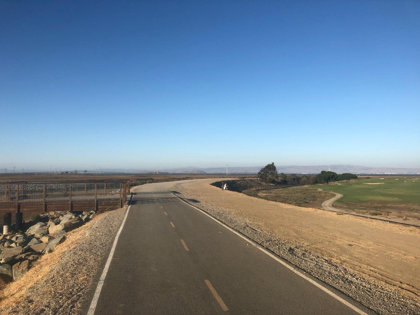
The trail departs Geng Road and climbs to the bank of San Francisquito Creek.
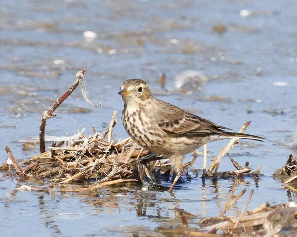
American Pipit by Brooke Miller
After 0.5 miles, you will reach the Friendship Bridge, which crosses the creek and heads to San Mateo County. The bridge is a good vantage point from which to scan up and down the creek in search of shorebirds, which may be foraging on the mud flats or resting on the rocky banks. The area around the bridge is a particularly good place to look for Spotted Sandpiper.
Stay on the San Francisquito Creek Trail to continue (don’t cross over the bridge). As you get closer to the bay, a wider variety of swimming birds will join the shorebirds and waders in the creek, particularly when the tide is high. Expect to see Green-winged Teal, Northern Shoveler, and American Coot, among other species.
The paved part of the San Francisquito Creek Trail ends at the Friendship Bridge, which connects to other trails on the San Mateo County side.
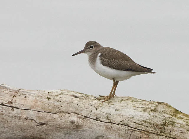
Spotted Sandpiper by Brooke Miller
Though the creek may command most of your attention, don’t forget to look to your right and scan the golf course. Look for a White-tailed Kite or Red-tailed Hawk hunting overhead, and search the Canada Goose flocks for any of their rarer cousins. Killdeer and Western Meadowlark may be seen walking on the golf course greens. Shrubs along the margin between the golf course and the trail harbor wintering White-crowned and Golden-crowned Sparrows.
As you continue toward the bay, the paved trail turns to hard-packed dirt and gravel, and the golf course gives way to the runways of the Palo Alto Airport. This open, grassy habitat is attractive to raptors, American Pipits, and Western Meadowlarks, though the small planes taking off and flying very low over this part of the trail are often a distraction. Black-tailed jackrabbits and California ground squirrels also call the airfield home.
At the 1-mile mark, you arrive at a conveniently placed bench overlooking the mouth of San Francisquito Creek. When the tide is sufficiently low to expose mud flats, they host a spectacular variety of shorebirds, ducks, and gulls, though many are too distant for satisfactory viewing without the aid of a scope. Distant Western and Clark’s Grebes swim in the bay, while Brown Pelicans and Forster’s Terns may be seen flying by. Locally rare shorebirds such as Black Oystercatcher, Ruddy Turnstone, and Red Knot all have occurred here recently, so keep an eye out for whatever rarity might be next!

The trail reaches a bench at the mouth of San Francisquito Creek. Turn right to continue toward the Lucy Evans interpretive center. (Pardon the shadow!)
If you leave the creek mouth itching for more, turn to the southeast and continue along the San Francisquito Creek Trail, which now runs parallel to the airport runways. The marshy channel parallel to the trail is crowded with hundreds of waterfowl from fall through spring. Expect to see plenty of Green-winged Teal, Mallard, and Northern Shoveler. Northern Pintail will also be around, sometimes in large numbers, though they seem hit-or-miss depending on the tide. Smaller numbers of Gadwall, American Wigeon, and Ruddy Duck should also be present, along with other swimming birds such as American Coot and Pied-billed Grebe. You may see one or more Cinnamon or Blue-winged Teal among the masses of more common ducks. Look for Black-crowned Night-Herons roosting in the marsh vegetation, and listen for Sora and Virginia Rail. Marsh Wren, Song Sparrow, and Common Yellowthroat also inhabit the marshes.
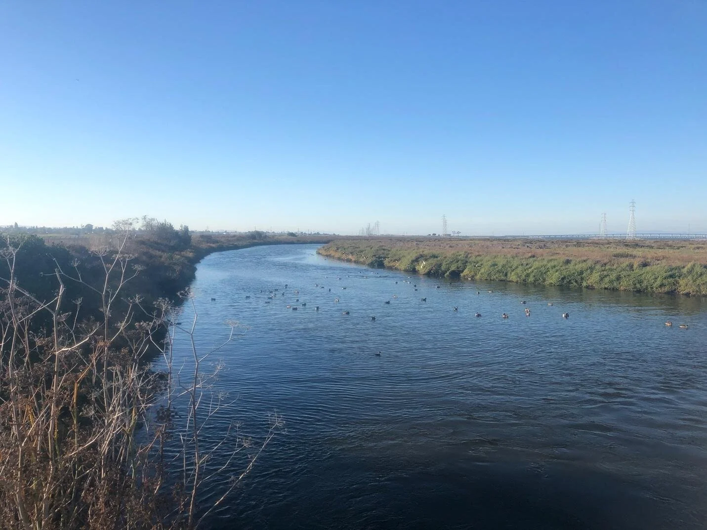
A variety of waterfowl forage in the channel along the trail.

Northern Pintail by Garrett Lau
A dusk visit may reward you with one or more Ridgway’s Rails giving their grating “kek-kek-kek” calls, which you are particularly likely to hear near the San Francisquito Creek mouth or the Lucy Evans interpretive center. If you are lucky, you may even see a Short-eared Owl in low, flopping flight over the marshes and open fields.

Ridgway’s Rail by Luis Villablanca
Another special bird to watch and listen for is the Swamp Sparrow (November through February), seen along this trail in recent years. This cousin of the Song Sparrow is common in the eastern U.S. but only a rare visitor to the Bay Area, where it spends the fall and winter skulking in marshy areas. The best area to look for this species is about halfway along the segment of trail parallel to the airport runways, and is marked by a round, ten-foot-high shrub, which is much larger than any other shrub or tree along this segment of trail. When you arrive at this shrub, scan the marsh grasses extra carefully, and double-check any sparrows you see along the edges of the trail. Listen for the Swamp Sparrow’s distinctive call, which sounds similar to the clear “chip” of a Black Phoebe.

A prominent shrub marks the traditional location to look for a Swamp Sparrow.

Swamp Sparrow by Brooke Miller.
After continuing past the Swamp Sparrow shrub and enjoying your fill of the duck hordes in the channel, you will reach the 1.5-mile mark of your trip. The trail takes another right-angle turn here and ends at the Lucy Evans interpretive center in 0.3 miles. You can continue to the interpretive center, or you can retrace your steps for a 3-mile outing, which will give you another chance to look for the Swamp Sparrow lurking in the marshes and those well-camouflaged shorebirds along San Francisquito Creek.
Ready for more?
To extend your trip, proceed to the interpretive center and enjoy birding the more familiar parts of the famous Palo Alto Baylands: Duck Pond Loop Trail and “Rail Alley”, described in a September self-guided trip. If you’re on bike you can make this a 3.1-mile loop trip. Leave the Baylands via Embarcadero Road, then turn right onto Geng Road to return to the parking area and complete your trip.
Interactive Map
Directions: If you are coming via US-101, take exit 402 for Embarcadero Road East, merge onto Embarcadero Road, and turn left onto Geng Road. If you are coming from Palo Alto, you can take Embarcadero Road all the way to Geng Road. Park at the city owned Baylands Athletic Center. Latitude/Longitude: 37.453253, -122.120825
Parking: Paved lot with plenty of parking spaces, five ADA Compliant.
Fees: None
Public Transportation: Not available
Park Hours: Opens at 8 AM. From November 1 through January 15, closes at 5:30 PM. (These hours are from the City of Palo Alto web page for the Baylands, but I think they refer to the gated parking off Embarcadero Road. I don’t know whether there are any restrictions on the hours for parking at Geng Road or using the trails.) The closing time is based on sunset, so it is later at other times of year.
Facilities: ADA-accessible bathrooms are available at the Geng Road parking area and at Byxbee Park. There’s a porta-potty in the Duck Pond parking lot. Lucy Evans visitor center, including its bathrooms, is still closed to the public due to the pandemic
Trip Mileage: 1.5 miles of trail each way, 3 miles round-trip
Trail Conditions and Accessibility: The trail is almost entirely flat, with only a very short incline from the parking area at Geng Road up to the trail on the creek bank. The 0.5-mile stretch of the San Francisquito Creek Trail from Geng Road to the Friendship Bridge is paved. From the Friendship Bridge to the Lucy Evans interpretive center, the trail is hard-packed sand. Though the trail is well-traveled by pedestrians and cyclists, especially between Geng Road and the Friendship Bridge, it is wide enough to facilitate social distancing. The entire route is in full sun, but also can be chilly due to wind blowing in off the bay. There is one bench at the mouth of San Francisquito Creek, and another bench overlooks the channel parallel to the airport runways, near the 1.5-mile mark.
Bikes: This is a great trip to do by bike!
Dogs: Allowed on 6-ft leash
More information
Palo Alto Baylands Website
Relevant eBird hotspots:
More Resources
For more trips like this one, visit Self-guided Field Trips.
Visit the SCVAS Birding Resources page for more information on where to bird, our birding community, birding identification resources, and more.
Read “What to Look for Now” by SCVAS Executive Director Matthew Dodder.
Banner Photo Credit: Green-winged Teal by Raminder Bajwa
Last Updated: 3/23/2022
Enjoyed this Trip?
Support the work of Santa Clara Valley Audubon Society and become a member. To contact the trip writer with comments, questions or location updates, please email fieldtrips@scvas.org. You can also post in the comment section below. (If you’d like to post anonymously, type your comment, select “Post Comment”, then simply provide a name, like “Guest”, and select “Comment as Guest”.)