
Stevens Creek County Park (Fall/Winter):
The Early Bird Catches the Worm, Acorn and Toyon Berry!
By Diane McCoy
If Stevens Creek County Park were to have a bird mascot, it would have to be the Acorn Woodpecker, a year-round resident. Like the first peoples who inhabited these foothills, the Ohlone, the Acorn Woodpecker makes good use of the plentiful acorns from the Coast Live Oaks dominating this area. Along with the Acorn Woodpecker and many other year-round resident birds, the fall and winter seasons bring even more bird species to be discovered and enjoyed in this Cupertino hills park.
Trip Covers: September - March
Key Birds: Red-breasted Sapsucker, Acorn Woodpecker, Downy Woodpecker, Wrentit, Ruby-crowned Kinglet, Brown Creeper, California Thrasher, Hermit Thrush, White-crowned Sparrows, Golden-crowned Sparrows, Yellow-rumped Warbler, Townsend’s Warbler
How to Bird
Located about 5 miles northwest of the city of Cupertino lies the 93-acre Stevens Creek Reservoir. Below the reservoir is the 1,042 acre Lower Stevens Creek Park which includes varied woodland, riparian, grassland, chaparral, and aquatic habitat. The preserve also includes upper Stevens Creek Park (1,095 acres) and sits right between Picchetti Ranch Open Space Preserve and Fremont Older Open Space Preserve. The creek winds out of the Santa Cruz Mountains on its way to San Francisco Bay in Mountain View.

Fall golden-colored big leaf Maple, a native plant, hangs over a portion of Stevens Creek. Stevens Creek and Stevens Creek Reservoir are named after Captain Elisha Stephens. Captain Stephans was an early pioneer, settler, and farmer in this area, specifically what is now Blackberry Farm, from 1848 to 1864. He had been one, in a group of three men, that led the first wagon train to cross the Sierra Nevada in California in 1844. His wagon train traveled through what is now Donner Pass two years before the famous Donner-Reed crossing. He reportedly built the cabin later used as winter shelter by several of the Donner party. Stephans farmed here, growing grapes, fruit trees, and blackberries.
We’ve chosen 3 stops in Lower Stevens Creek Park and 2 stops along Stevens Creek Canyon Road to help get you started in exploring this park. Try to get to the park as early as possible, for the most optimal birding. Your first stop will be the Chestnut Picnic Area (#1 on interactive map) where you can explore woodland, grassland, and riparian habitats. Your second stop will be the Villa Maria Picnic Area (#2 on interactive map) that can begin with a vista overlook and further explores woodland habitat including the ‘famous’ Umbrella Tree, an Acorn Woodpecker granary extraordinaire! For your third stop, you will be taking a flat walk along the Tony Look Trail for views of the south side of the reservoir (#3 on map). The fourth and fifth stops will be back up on Stevens Canyon Road a bit, at the Boat Launch (#4) and Lakeshore Picnic Area (#5).
Stop 1: Chestnut Picnic Area
The Chestnut Picnic Area parking lot (#1 on the interactive map) will be the first left hand turn as you come off Stevens Canyon Road into the park’s main entrance. The Chestnut area includes the parking lot and pay station, two picnic areas, restrooms (although may be closed in ‘off season’), and short, mostly flat, meandering trails (see county park map). The trails that meander through this area and connect the two picnic areas pass through wooded, grassland, and riparian habitat. Some of the trees in this area include grafted walnut and chestnut trees from previous orchard farmland days, eucalyptus, California Laurel, Big Leaf Maple (turning fall-golden), California Buckeye and the Coast Live Oak.

Trails meander through varied woodland of oaks, laurel, eucalyptus, and more, comprise the different habitats of the Chestnut Picnic Area. The path on the left leads down to the creek.
Starting in the parking lot scan the area for wintering White-crowned and Golden-crowned Sparrows foraging on the ground with year-round residents Dark-eyed Juncos, Spotted Towhees and California Towhees. Acorn Woodpecker calls will greet you almost immediately while Brown Creepers and White-breasted Nuthatches forage on the tree trunks. While still in the open area of the parking lot, look skyward for Red-tailed and Red-shouldered Hawks, Cooper’s, Sharp-shinned, Turkey Vultures, and even Golden Eagles. Band-tailed Pigeons occasionally fly over as well.
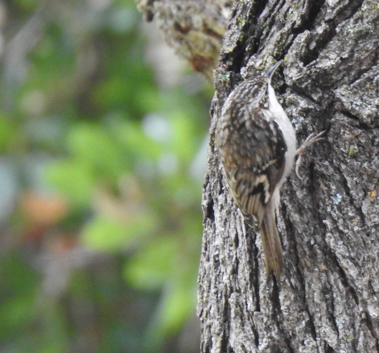
The Brown Creeper, a year round bird, also likes the grafted walnut trees, probing and pecking for insects with a curved beak. Creepers climb upward, spreading out their legs/feet which have long, curved claws that hook onto the bark. When done in one spot they will fly over to the bottom of another tree trunk and start up again.

Spotted Towhee by John Scharpen

White-crowned Sparrow

Golden-crowned Sparrow. Both White- and Golden-crowned Sparrows breed in Alaska and Northern Canada. White-crowned Sparrows have a bit bigger breeding range than the Golden-crowned Sparrows. Both migrate as far south as Baja California with White-crowned Sparrows going as far south as Mexico.
As you leave the parking lot, choosing one of three paths at the end opposite from the pay station (going towards the picnic areas), you will start to enter varied wooded, grassland, and riparian habitat. Quietly scan, with eye and ear, the ground, bushes and trees for the wintering Northern Flickers (Red-shafted), Yellow-rumped Warblers, Townsend’s Warblers and Ruby-crowned Kinglets. Year-round residents California Scrub and Steller’s Jays, Hairy and Downy Woodpeckers, Oak Titmice, White-breasted Nuthatches and Chestnut-backed Chickadees are here as well.

Oak Titmouse by Suresh Thirumalai
While walking, you may spot several native perennial Toyon bushes blooming with vibrant red berries this time of year. The Toyon is California’s winter holly bush and both Cedar Waxwings and Hermit Thrush, winter residents, and American Robins, love eating the berries.

Cedar Waxwings are named for the waxy red tips on the end of their secondary feathers. The number of tips and their size increase as the bird gets older. These birds love fruit and can survive several months on just fruit, occasionally becoming intoxicated from fermented berries. Waxwings take turns in small groups, called museums, eating and they do not ‘sing.’ Instead they make a trilling or buzzing sound.
From the smaller picnic area closest to the parking lot, stop on the little bridge that goes over Stevens Creek, a good place to scan for warblers and kinglets. Can you spot the small, white Snowberries bursting out now, right at the sides of the creek? These are also a favorite for waxwings, as well as thrushes, robins, towhees and even sometimes the Yellow-rumped Warblers. Snowberries bud only in fall and winter.

Snowberries, budding only in the fall and winter, provide food for year-round resident and wintering birds.

Bridge going over Stevens Creek that adjoins the two small picnic areas located in the Chestnut Picnic Area.

Yellow-rumped Warblers, also known as ‘butter butts,’ are the only warbler to digest the wax on some berries. Common and abundant in numbers, this warbler is streaked in brown-gray with a hint of yellow under its throat, wings and on the top of its rump. Breeding far north in Alaska and north Canada its feathers will intense into brilliant yellow, dark gray and black, and bold white.
As you follow the bridge (shown on the interactive map) and path over into the ‘main’ Chestnut picnic area you will see farm-planted Chestnut trees and the native Buckeye tree; leafless with small pear-like nuts adorning the branches. Buckeyes are actually quite toxic. Squirrels can feed on them as they know which ends are not poisonous!

Seed pod from the Buckeye tree.
This more open area is good to once again scan the sky. Lots of protective bushes and trees line this picnic area for the seed and insect eating birds. Very early in the day, California Quail sometimes come out and forage further along the path that goes past the restrooms. The path through the center of the picnic area dead ends but can be a place to keep an ear and eye out for Bewick’s Wrens.
Stop 2: Villa Maria Picnic Area
There are two ways to get to the next stop, Villa Maria (#2 on map). To walk, take the path behind the Chestnut Picnic Area restrooms (shown on the interactive map). It’s a short, not too steep zig-zag path up the hill.
The alternative route would be to return to your car and drive up to the Villa Maria parking lot, following the signs. You will pass over the creek and pass the nature/ranger station on your right, keep to your left up the hill.

Zig-zag path up the hill that adjoins the Chestnut and Villa Maria Picnic Areas.

The Villa Maria parking and picnic area was so named by the Santa Clara University Jesuit priests. This property was purchased and developed by the Jesuits in 1870. It was developed as a working farm, winery and weekend retreat for the Jesuits. It included 100 acres of vineyards, walnut, olive, apple, apricot, and chestnut orchards. The Jesuits also planted non-native eucalyptus, pines, and cypress here. Profits were used to fund the college.
The Villa Maria Picnic Area has more parking and picnic tables than the Chestnut Picnic Area and is dominated by the Umbrella Tree which is at the end of the parking lot and behind the restrooms. This tree is in the pine family and is ‘famous’ for its acorn granary created by the Acorn Woodpeckers. It's truly amazing to see the number of holes along its trunk and branches that the woodpeckers have made to store acorns.

This Umbrella Tree is also an Acorn Woodpecker granary.

The woodpeckers carefully maintain their granary protecting it from squirrels and jays! The acorns are shifted around to different holes as they shrink when dried out.
Take a moment to sit on a picnic table bench and enjoy observing all the activity in this area. Ground seed and insect eating sparrows and juncos reappear, as do towhees and robins. Western Bluebirds flit in branches of younger trees. Nuttall’s Woodpeckers and White-breasted Nuthatches can be spotted here as well.

The White-breast Nuthatch scales up and down trees while using their slightly upturned bill for foraging out seeds and insects. Sparrow-sized, these birds have no visible necks but large heads.

Western Bluebird
American Crows are here, Anna’s Hummingbirds may flit by, Mourning Doves may perch early in the day, and a Hairy or Downy Woodpecker can often be heard. Both these woodpeckers look very much alike with similar white on black patterning and red spot on nape in the males. Hairy Woodpeckers are about 3 inches longer than Downy Woodpeckers and have a long beak which is nearly as long as the bird’s head. Downy Woodpeckers have tiny, stubby beaks. A Downy Woodpecker’s call is a short, very high pitched ‘pik,’ while the Hairy’s call is like a squeaky dog’s toy.

Note that the small beak of the Downy Woodpecker is about 1/2 the length of its head.
Also in this area is a bit of a vista. The vista will be to your right at the top of the zig-zag path from Chestnut Picnic Area. If you drive up, the path is near the very large, multi-trunked Bay Laurel, to the left of the restrooms. Digger Pines with their very large cones surround you at the vista overlook as do native Madrone, Coyote Bush and other plants. The view looks north-east with clear skies overhead to view raptors.
Stop 3: Tony Look and Loop Trail
There are two options for getting to the reservoir; walk/hike or driving. If you would like to hike to see the reservoir, start at the ranger/nature station where a large sign and map will direct you to the Tony Look and the Loop Trails (#3 on map). Otherwise, skip this section and read about Stops 4 and 5.

Trail entrance to the Tony Look Trail. The Tony Look Trails follows along the west side of the reservoir.

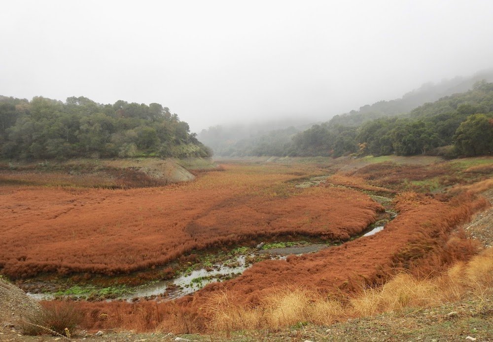
Stevens Creek Reservoir.
Follow the Tony Look Trail, which runs past the dam and alongside the west edge of the reservoir, for 0.7 miles. It is mostly an easy wide, flat, dirt-packed trail. There is one part that has a steep incline, but it’s short. As you pass the reservoir’s spillway, you’ll get a wide open view of the reservoir and open sky for viewing raptors. After passing the spillway, the path exposes some chaparral habitat so keep an eye and ear out for Wrentit, California Thrasher, California Quail, California Scrub-Jay, Bewick’s Wren, Anna’s Hummingbird and Bushtits. Wrentits most likely will be heard before seen. Listen for their ‘scolding’ churring sound from the bushes. Black-backed, white and orange chested Spotted Towhees may also be cautiously hiding while foraging on the ground here.
If you’d like, continue along the west edge of the reservoir for another 0.3 miles using the the short Loop Trail before returning the way you came.
Launch Ramp Area and Lakeshore Picnic Area: Stops 4 and 5
To drive to the other two reservoir stops go back to Stevens Canyon Road, making a left at the park’s entrance onto Stevens Canyon Road. There are two good viewing spots of the reservoir a short distance away. The first stop, the Launch Ramp area (#4 on map), is on your left in 0.7 miles. There is plenty of parking here and because the reservoir is so low you can walk out to where the boats would otherwise be launched into the water.

Walking to the water’s edge at the Boat Launch area.
This is a good vantage point to see the birds on this side of the reservoir. Mallards, Double-crested Cormorants, American Coots and Canada Geese are usually here. Be on the lookout for Hooded and Common Mergansers and even Spotted Sandpipers, all three species over-winter here.

Common Merganser males have all black heads, mostly white bodies and a bright orange beak. The red-headed Common Mergansers can be either females or juvenile males.

Spotted Sandpipers migrate here from their breeding grounds in northern US states, Canada, and Alaska.

Male Hooded Mergansers have a distinctive black and white crest on their heads and black and white stripes on their chests. Hooded Mergansers are the smaller of the two merganser species
The second reservoir stop is the Lakeshore Picnic Area (#5 on map) which is just beyond the Launch Ramp area, about 1.2 miles from the Stevens Creek Park main entrance (or 0.5 miles from the Launch Area parking lot). Watch for a wood fence for the turnout, as there is no sign posted on the road.
In this area, watch again for Yellow-rump Warblers, jays, Oak Titmice, Chestnut-backed Chickadees, White-breasted Nuthatches, White-crowned and Golden-crowned Sparrows flitting in the trees or foraging on the ground all around the picnic area.
When you walk down to view the reservoir, take time to also scan to your right, towards where the creek is feeding into the reservoir. Raptors including Northern Harriers, Red-tailed Hawks, Turkey Vultures and Red-shouldered Hawks fly over this area.
Stevens Creek viewed from the Lakeshore Picnic Area.
Ready for More?
While in the area, consider visiting Picchetti Ranch Open Space Preserve, Blackberry Farm or McClellan Ranch Preserve. We have fall and winter guides for all these areas.
Picchetti Ranch OSP (Winter): Oak Woodland Waiting for the Rains
Blackberry Farm (Fall/Winter): A Riparian Corridor in Silicon Valley
Or, come back to Stevens Creek County Park in the spring or summer. Check out our self-guided trip:
Interactive Map
Directions: From I-280 in Cupertino take Foothill Expy exit. Continue south on Foothill Blvd for about 2 miles (it becomes Stevens Canyon Rd). Turn left into the first park entrance and meet in the Chestnut Picnic Area parking lot (first parking lot on your left). Latitude/Longitude: 37.306812, -122.073302
Parking: Paved parking lots, including handicapped parking spaces.
Fees: Vehicle entry fees are collected year-round. Ticket will cover all spots described in this guide. Pay machines are located in the Chestnut and Launch Ramp parking lots.
Public Transportation: none available
Park and/or Trail Hours: The park is open all year-round from 8 am to sunset, trails are open sunrise to sunset.
Facilities: Wheelchair accessible bathroom at Villa Maria Picnic area. Porta-potties at Lakeshore Picnic Area. Picnic tables at all spots described except the Launch Ramp area.
Trip Mileage: Variable, you’ll be meandering several picnic areas and there is one 2 mile hike included in this guide.
Trail Conditions: Packed dirt, some roots, rocks, etc. Poison Oak edges some of the paths in the Chestnut Picnic area. Chestnut and Lakeshore areas are shaded.
Accessibility: The trails are not accessible in this park but the Chestnut and Villa Maria Picnic Areas are great for parking lot birding.
Bikes: Bicycles allowed on posted trails only. ANSI/Snell approved helmets are required for all children under age 18. Helmets are required for all bicyclists.
Dogs: Dogs must be controlled on a 6- foot (or less) leash at all times. Not allowed in the water or on the Creek or Zinfandel Trails. Allowed in all picnic areas and other trails.
More Information:
Stevens Creek County Park Trail Map
Stevens Creek County Park Website
Stevens Creek County Park Site Guide created by Environmental Volunteers
Early Days of Stevens Creek - Villa Maria Farm and Winery History by John Seyfarth
More Resources
For more trips like this one, visit Self-Guided Field Trips.
Visit the SCVAS Birding Resources page for more information on where to bird, our birding community, bird identification resources and more.
Read “What to Look for Now” by SCVAS Executive Director Matthew Dodder.
Photo Credits: Banner Photo: Acorn Woodpecker by John Richardson, all other photos by Diane McCoy unless otherwise stated.
Last Updated: 5/19/2022
Enjoyed this Trip?
Support the work of Santa Clara Valley Audubon Society and become a member. To contact the trip writer with comments, questions or location updates, please email fieldtrips@scvas.org. You can also post in the comment section below. (If you’d like to post anonymously, type your comment, select “Post Comment”, then simply provide a name, like “Guest”, and select “Comment as Guest”.)