
Byxbee Park and Palo Alto Regional Water Quality Control Plant (Winter):
Waterfowl and Migrant Birding at an Artsy Palo Alto Baylands Preserve
by Diane McCoy
Byxbee Park, in the Palo Alto Baylands Nature Reserve, features a hill with a 360-degree vista, grasslands studded with conceptual art, marshy sloughs, a creek and tree-lined paths, throughout which you can find wintering waterfowl, migrating passerines, soaring raptors and a variety of gulls.
Trip Covers: October - March
Key Birds: Greater White-fronted Geese, Cackling Geese, winter ducks, Curlews, sandpipers, Bonaparte’s Gull, Short-billed Gull, Short-eared Owl, Say’s Phoebe, American Pipit, White-crowned Sparrow, Golden-crowned Sparrow, Lincoln’s Sparrow, Common Yellowthroat, Yellow-rumped Warbler
How to Bird
Lying right between the Palo Alto Baylands and Emily Renzel Wetlands is Byxbee Park and Palo Alto’s Regional Water Quality Control Plant (RWQCP); a right turn at the very (east) end of Embarcadero Road. Byxbee Park was named for John Fletcher Byxbee Jr., Palo Alto City Engineer from 1906 to 1941. Byxbee was a graduate of both Palo Alto High School and Stanford University. Previously the Palo Alto city landfill, the park was created in 1991 after the city started to enact recycling practices and contracted with Mountain View and Sunnyvale’s Materials Recovery and Transfer (SMaRT) Station to receive and sort Palo Alto’s garbage.
The wide, dirt-packed trails of this park were designed to create plenty of recreational space for joggers, walkers and birdwatchers. The approximate 30 acres of this park, is bordered by Mayfield Slough, a bit of Matadero Creek, the RWQCP, and surrounded by marshland. It lies underneath the flight path of small planes that use the Palo Alto Airport. Be sure to arrive early, the main parking lot and the adjacent small overflow parking lot can fill up.

“Wind Waves”, one of many earth-work art displays unique to Byxbee Park. Photo by Diane McCoy.

Main parking lot at Byxbee Park. Restrooms and trail heads are at the far end. Photo by Diane McCoy.
There are three areas to explore in this park: the flat, paved trail around the hill for views of Mayfield Slough, the hills of Byxbee Park, and the native plantings around the RWQCP.

One of the year-round resident raptors of the baylands, Northern Harriers have a distinctive white on their rump. Females are brown, males gray. Using mainly sound to find prey in the salt-plant marsh, notice their face feathers look somewhat ‘owl-like.’ Photo by Diane McCoy.
Before you start exploring the area, you can begin your birding right away at the parking lot (#1 on interactive map). On early winter mornings the trees and hillside in the parking area can be lively with winter Yellow-rumped Warblers, Bushtits, Oak Titmouse, Chestnut-backed Chickadees, Anna’s Hummingbirds, House Finch, Lesser Goldfinch, and Mourning Doves. Scan the ground and hillside for White and Golden-crowned Sparrows, Dark-eyed Juncos, and maybe a Lincoln’s Sparrow. California Towhees like it here also.
On the other side of the parking lot is the marsh. Looking east, you can see the boathouse building, the EcoCenter, at Palo Alto Baylands. Scan the marsh for year-round residents like Northern Harriers, and Snowy and Great Egrets. Closer in front of you, search the tidal creek for Greater Yellowlegs, Common Yellowthroat, Killdeer, Song Sparrow, and Marsh Wren.
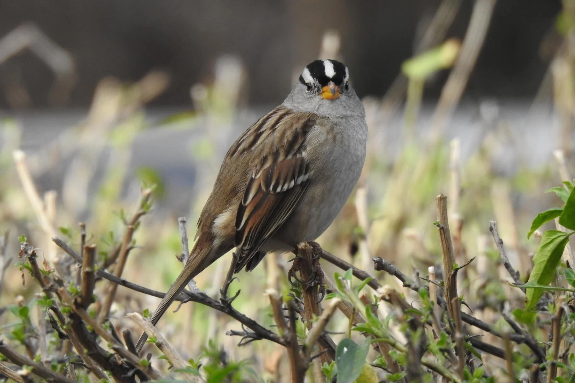
The White-crowned Sparrow, a winter migrant, can travel over 2,600 miles from Alaska to California in winter. They often show ‘territory loyalty’ by returning to the same area each winter. When returning in the spring they will average a distance of about 70 miles a day. Photo by Diane McCoy.

The wintering Lincoln’s Sparrow is very secretive. It sneaks around wet vegetation looking for insects and seeds. It’s in the same genus as Song and Swamp Sparrows. Photo by Diane McCoy.

The Common Yellowthroat feeds mainly on insects, but sometimes spiders and seeds. It was one of the first species of birds to be described from the new world, by Linnaeus in 1766. Photo by Diane McCoy.

The Yellow-rumped Warbler eats insects but also berries. It is the only warbler able to digest wax found in bayberries and wax myrtals giving this bird a wider range during migration. Its nickname is butter-butt! Photo by Diane McCoy.
Adobe Creek Trail and Mayfield Slough
After birding the parking lot, it’s now time to take the Adobe Creek Trail around the hill for views of Mayfield Slough. This walk can be as long as 2 miles or as short as ½ mile. Starting from the main parking lot and restroom area, travel northeast towards the precast highway barriers and the 72 truncated telephone poles (the first earthwork art installations). Take a few moments to scan the area. Bewick’s Wren and Song Sparrows scold and serenade you along the trail. Sometimes a Ridgway’s Rail can be heard calling from the reeds in the marsh. Keep an eye out for Western Meadowlarks, American Pipits, and Canada Geese on the hillside.

The shy American Pipit is one of very few species of American songbird that nests in the Arctic Tundra and alpine meadows. They eat mainly insects and their larvae. Photo by Diane McCoy.

The Chevrons - repurposed freeway barriers. The barriers were set here in the design of an arrow, ‘guiding’ small planes to the landing strip at nearby Palo Alto Airport. The barriers also slow down runoff, diminishing polluted water going into the bay and creating humid micro biotopes. Can you spot the small plane in the photo? Photo by Diane McCoy.

The 72 repurposed telephone poles visually connect the site to other utility poles across the bay. Though individually different in height, the poles all reach the same height on the sloped hill. Photo by Diane McCoy.

Trail marker. Photo by Diane McCoy.
At the trail signpost take a right turn following the trail that says ‘1.7 miles to Renzel Wetlands’ (#2 on interactive map). On your left will be Mayfield Slough and on your right the hillsides of Byxbee Park. When viewing the Canada Geese here, keep an eye out for a migrating goose such as a Cackling Goose, and/or a Greater White-fronted Goose, and though it’s more rare, Snow or Ross’s Goose.

In winter, Greater White-fronted Geese usually flock with Snow Geese or Canada Geese. They nest in the tundra and mate for life. They have one of the largest ranges of goose in the world. Photo by Diane McCoy.

First described by Audubon in 1844, Western Meadowlark males may have two mates at one time. Pecking and scratching on the ground they mostly eat insects, but seeds and grain as well. A group of meadowlarks is called a pod. Photo by Vivek Khanzode.
Again, the hillsides are also frequented by American Pipits and Western Meadowlarks. Along with these small birds, Jack Rabbits and Ground Squirrels, mice and moles may draw the attention of Red-tailed Hawks, Cooper’s Hawks, Northern Harriers, occasionally White-tailed Kites, and Turkey Vultures. Bald Eagles occasionally have flyovers here as well. In the very early dawn or more often at dusk Short-eared Owls may prey on small birds and mammals here, and American Crows and Common Ravens are year-round residents. Scan the bushes that you see on the hillsides and any scags, for Say’s Phoebe, Western Bluebirds, Yellow-rumps, Lincoln’s and Savannah Sparrows.

Short-eared Owls travel great distances during migration; 1,200 miles and sometimes over wide open ocean. One of the few owls that build nests on the ground, they breed in all of northern Canada and Alaska. They are most active in the evening, but in daylight as well. They fly low to the ground with wing beats that make them resemble a moth. Photo by Garrett Lau.

Say’s Phoebe (upper left) and Savannah Sparrow. The Say’s Phoebe was named for the American naturalist, Thomas Say. Common across western North American, this flycatcher breeds further north than any other flycatcher; Northern Canada and Alaska. Photo by Diane McCoy.
Winter is such a good time to see many ducks in the Mayfield Slough, and both winter migrants and resident birds may change from day to day. That said, the Northern Shoveler will be here most of the winter, along with plenty of Ruddy Ducks and year-round Mallards, Double-crested Cormorants, and American Coots. Scan the water carefully though, as Cinnamon Teal, Green-winged Teal, American Wigeon, Gadwall, Goldeneye, Canvasbacks, Buffleheads, and Scaups can appear as well. Along the shoreline look for Avocets, Black-necked Stilts, and Killdeer. Snowy and Great Egrets and Great Blue Herons are here year round, but keep your eyes open for wintering Long-billed Dowitchers, Curlews, and Least and Western Sandpipers. Along this same trail look just ahead and often White and Golden-crowned Sparrows will be foraging on the trail’s edges, fluttering into the bushes as you pass by where Ruby-crowned Kinglets might be, feeding on bush leaf insects. Lincoln’s Sparrows are sometimes among the crowned sparrows.
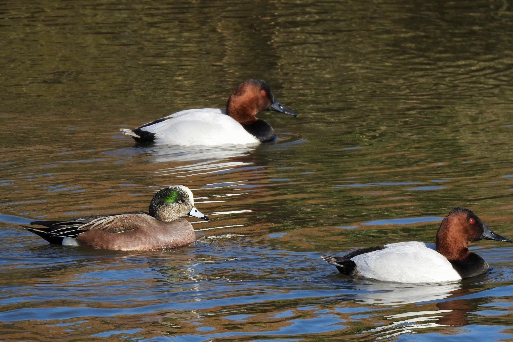
Similar in size, wintering Canvasbacks (whitish-gray backs) and American Wigeons breed in north-west US states, Canada, and Alaska. Wigeons are dabbling ducks while Canvasbacks dive for food. Photo by Diane McCoy.

The smallest dabbling duck native to America is the wintering Green-winged Teal. They are one of the fastest flying game birds; 97 mph! But they can walk and run on land well. They are good swimmers and though they are dabbling ducks, they can dive quite well to escape predators. Their mating dance is quite elaborate. Photo by Diane McCoy.

The Long-billed Curlew is the largest shorebird in North America. Nicknamed ‘the candlestick bird,’ Candlestick Point in San Francisco was named after this bird. Wintering here in the mud flats of the bay area, the curlew will eat crustaceans, mollusks, and sometimes seeds. To take off, the curlew has to jump, then flap and eventually glide up into the air. Photo by Diane McCoy.

The sparrow-sized Least Sandpiper is the smallest shorebird. Their yellowish-green legs (unless covered in mud) can be helpful in distinguishing them from the similar-looking Western Sandpiper, also abundant here in winter. These small sandpipers fall into the category of “peeps.” They breed in the subarctic and Low Arctic. Photo by Diane McCoy.
After you have gone about ¾ of a mile there will be eucalyptus and sycamore trees on the slough side of the trail. Yellow-rumped Warblers, Bushtits, sparrows, and Ruby-crowned Kinglets may be seen fluttering about. As you continue along the trail you will notice the slough narrows into a creek; Matadero Creek begins here. Often you can get a closer view of the ducks in the creek and Savannah Sparrows frequent this area, on the creek side.
About now you will come to about the 1.20 mile mark with a choice in trails (#3 “Choices, choices” on map). You can either turn around and go back the way you came, continue straight, keeping the creek on your left, or go back to the parking lot by going up and over the hill.

Choices, choices. Continue around the hill or walk to the top. Photo by Diane McCoy.
If you continue straight, the trail can take you to Emily Renzel Wetlands or you can make a right hand turn to make a loop back to the parking lot (see map). If you choose to continue straight, you may see year-round birds such as Black-necked Stilt, Snowy and Great Egrets and wintering Green-winged Teal. The third option is to go uphill, a very gradual slope up to the ‘top’ of Byxbee Park and its hills. This area is covered in the next section.

Savannah Sparrows are named after Savannah, Georgia where the species was first identified by famed ornithologist Alexander Wilson. This year-round little sparrow has a telltale yellow spot right above its eye making it a bit more distinguishable from other streaking brown sparrows. Like most sparrows it forages on the ground for seeds and insects. Photo by Diane McCoy.
Byxbee Park Hills
Now it’s time to explore the hilltop of the park. The trails criss-cross up here so there is lots to explore. As you walk up the trail you will start to notice vegetation islands. Part of the design of the park is to incorporate native plants up and all around the hilltop trails.
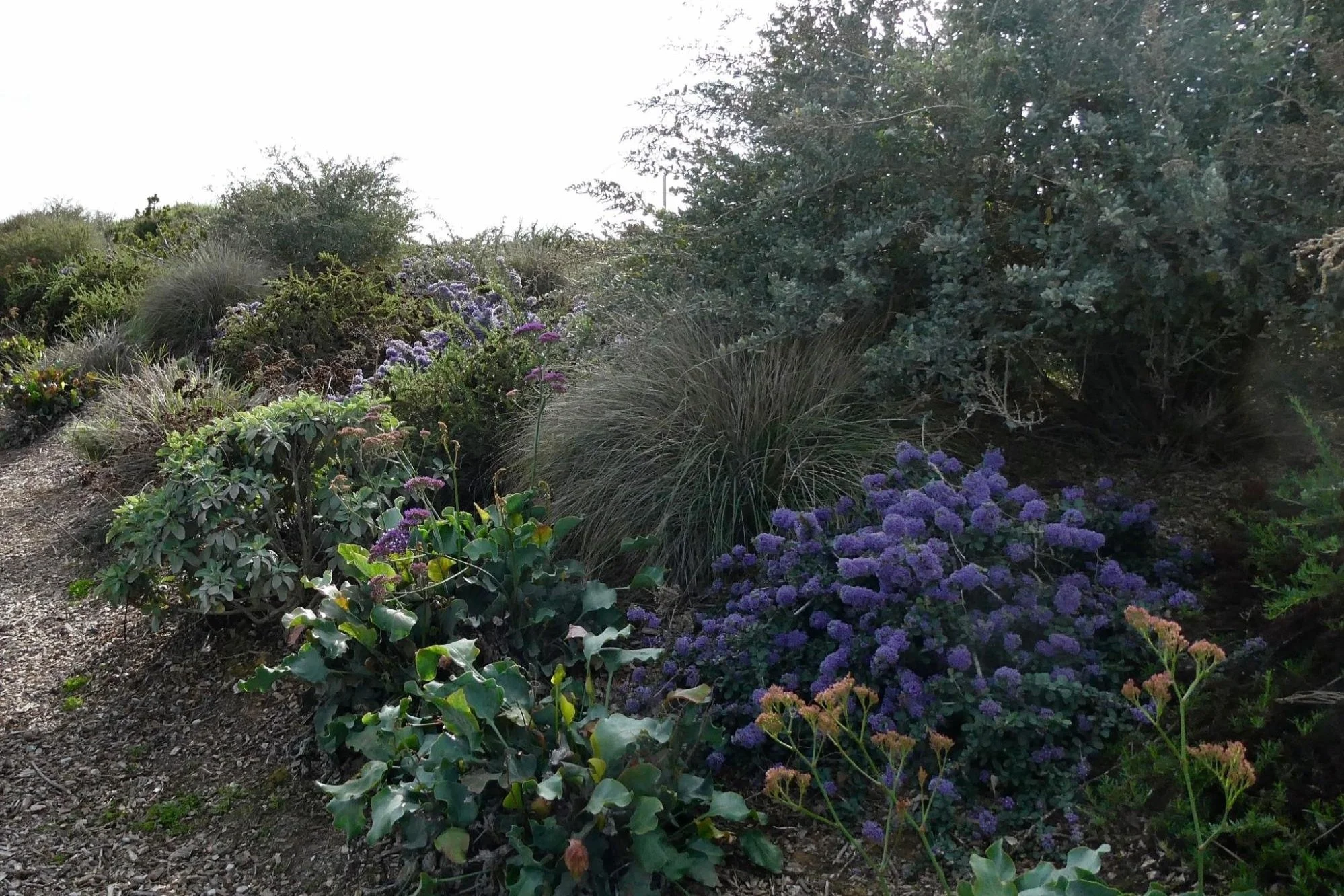
Some of the native plants used in Byxbee Park include sea lavender, saltbush, wild buckwheat, California sagebrush, longleaf wattle, lodgepole pine, manzanita, California lilac and buckbrush. Photo by Diane McCoy.
You will also notice narrow, 4 feet high metal posts studding the hilltops. These are methane cap markers; reminders that all this used to be a dump! Walk slowly, quietly and scan the markers and hillsides here for American Kestrel, White-tailed Kites and Say’s and Black Phoebes that land on these ‘handy’ perches. Good place to look for prey; gophers, moles, lizards, insects.

This American Kestrel is a female, rust color all around. Males have slate blue wings and the top of their heads. They often bob their tails when perched. Kestrels are dove-sized with a larger head. When flying they often bend their wings and the wingtips are swept back. A resident raptor here in the bay lands, it is sometimes called the sparrow hawk and is the smallest falcon in North America. Photo by Diane McCoy.

White-tailed Kites do indeed ‘kite.’ They hover in place with rapidly beating wings in the air over fields looking for small rodents. Facing into the wind they can maintain this position for quite a while. Sighting prey they will dive and capture it in their talons. Photo by Diane McCoy.
These upper hillsides are good places to spot Western Meadowlarks, Pipits, and Cowbirds and other seed and small insect and worm eating birds. When you are done exploring the hill, return to the parking lot.
Palo Alto Regional Water Quality Control Plant
If you have a little more time, be sure to explore the native plants around the Palo Alto Regional Water Quality Control Plant (#4 on the map). There is a short, wide dirt-packed trail that wraps around the south and east side of the plant. This area can be reached on foot from the Byxbee parking lot, or you can drive from the Byxbee parking lot north towards the airport, turn left on Embarcadero Road, then turn left again on Embarcadero Way and drive to the end and park along the street. The trail starts at the end of the street (parking shown on map ); plenty of free street parking is available.

Palo Alto Regional Water Control Plant Trail. Photo by Diane McCoy.
The trail is lined with tall eucalyptus and sycamore trees and some pines, as well as many shrubs. Many smaller birds flutter here, including Yellow-rumped Warblers, sparrows, juncos, Oak Titmouse, Anna’s Hummingbirds, Bushtits, Bewick’s Wren, and many Lesser Goldfinch. California Towhee can be heard and spotted as well, usually kicking around in the leaf litter on the ground. Notice the native plant landscaping, including the Toyon Bush, on the east side of the control plant. Standing on the trail quietly in front of this garden many birds can be spotted: California Towhee, White and Golden-crowned Sparrows, Lesser Goldfinch, Bewick’s Wren, to name just a few, enjoying the sun, the bugs, and the seeds.
From several places along the path, gulls may be seen flying to and fro from the top of the RWQCP, a favorite place for them to congregate, any time of the year. Ring-billed and California Gulls are common to see here, but Short-billed, Bonaparte’s, Herring and Glaucous-winged Gulls have been spotted flying around here, especially in the winter months.

Bonaparte’s Gulls breed in the boreal forests of Alaska and across Canada. They are the only gull that nests in trees. They are one of the smallest gulls and are most closely related to the slender-billed gull. The Bonaparte’s Gull was named after French ornithologist Charles Lucien Bonaparte (nephew to emperor Napoleon Bonaparte). Charles Lucien spent eight years in America adding to the study and grouping of birds. Photo by Diane McCoy.
Though smaller in size than some open space preserves, Byxbee Park can offer a different birding experience with every visit and is truly a special and unique place.
Ready for More?
There is so much to explore in and around Palo Alto Baylands. Try Emily Renzel Wetlands, Charleston Slough, or San Francisquito Creek Trail. Please visit our self-guided field trip page to see all the possibilities.
Interactive Map
Directions: From US-101 in Palo Alto, take Embarcadero Rd east towards the bay. Pass the airport and turn right at the T-intersection. The parking area will be at the end of the road. Latitude/Longitude: 37.450960, -122.106551
Parking: No parking fees. Byxbee Park has two parking lots; the main one is close to the restrooms and beginning of trails, and a smaller ‘overflow’ (dirt) lot on your right just before you drive into the main lot. (Both are shown on the map.) The main lot has disabled parking slots. If both lots are full, there is usually available space in the very first parking lot at the Palo Alto BayLands Preserve, on your right as soon as you drive through the gate (see map). The distance from this lot to Byxbee Park is 0.55 miles. A dirt-packed trail takes you from this lot to Byxbee along a tidal creek, for additional birding! Parking is also allowed on Embarcadero Road but only on the north side, the side across from the Water Control Plant.
Public Transportation: none available
Park and Trail Hours: 8 am to sunset
Facilities: Wheelchair accessible restrooms, drinking fountain, lots of benches and viewing decks, cell phone service. Only one restroom building at the beginning of the trails, by the main parking lot. One picnic table where the main parking lot is.
Trip Mileage: Variable
Trail Conditions: Wide, dirt-packed with gravel trails; well maintained. Lots of sun exposure; no shade. Can be more populated on weekends and holidays. Kites, drones, and radio controlled models are all prohibited in the park; airport nearby.
Accessibility: Though the trails have some gravel, they are nice and wide and well dirt-packed so that wheelchairs could manage the terrain, unless dampened by rain. The trail(s) by the main parking lot, along Mayfield Slough, and next to the RWQCP are all wheelchair accessible.
Bikes: Bikes are allowed and are popular on the trails. Motorized vehicles are prohibited on the trails.
Dogs: Dogs are allowed on 6-ft leash and can be popular on the trails. Doggy ‘poop’ bag/trash stations are available in several places on the trails.
More Information
City of Palo Alto: Byxbee Park
eBird hotspot: Byxbee Park
Visit the Society of Architectural Historians Archipedia page for more information on the art installations in this park
More Resources
For more trips like this one, visit Self-Guided Field Trips.
Visit the SCVAS Birding Resources page for more information on where to bird, our birding community, bird identification resources and more.
Read “What to Look for Now” by SCVAS Executive Director Matthew Dodder.
Banner Photo Credit: Canvasbacks and American Wigeon by Diane McCoy
Last Updated: 3/23/2022
Enjoyed this Trip?
Support the work of Santa Clara Valley Audubon Society and become a member. To contact the trip writer with comments, questions or location updates, please email fieldtrips@scvas.org. You can also post in the comment section below. (If you’d like to post anonymously, type your comment, select “Post Comment”, then simply provide a name, like “Guest”, and select “Comment as Guest”.)