
Sunnyvale Water Pollution Control Plant (Summer):
Phalaropes in the East Pond
by Eve Meier
July through September are the months to see the small and graceful Wilson’s and Red-necked Phalaropes. These birds are usually found on the East and West Ponds of the Sunnyvale Water Pollution Control Plant. And, if you are lucky, you may even see them spin!
Trip Covers: July - September
Key Birds: Wilson’s Phalarope, Red-necked Phalarope
How to Bird
Sunnyvale Water Pollution Control Plant has two large treatment ponds with tule-lined canals running along the outside edges of each. Quiet, uncrowded trails wrap around both ponds. This guide covers the 1/2-mile walk out to the east pond where you are most likely to see Wilson’s and Red-necked Phalaropes.

Red-necked Phalarope in August by Tom Grey
Wilson’s Phalarope in August. Tom Grey
Access the Bay Trail from the street parking on West Caribbean Dr (#1 on map). Follow the trail towards the bay, keeping Moffett Channel on your right. At the next trail intersection (#2 on map), keep to the right again as you follow the trail to just before the radar tower.

Radar tower
Along the way, check the channels for the stocky Green Heron hidden in the shadows and a Snowy Egret or two stirring up the mud with their flashy yellow feet as they walk along the edges of the water. The reeds will be busy with noisy Marsh Wrens, Common Yellowthroats, Song Sparrows and Red-winged Blackbirds. Often large numbers of Cliff and Barn Swallows congregate on the wires. (Also keep your eyes open for the rare Bank Swallows that are sometimes spotted here.) And be sure to check the dead-end of the channel closest to the radar tower for Common Gallinules with their bright red bill and large webbed feet.

Common Gallinule by Michelle Nelson
Walk through the gate on your left (#3 on interactive map). Now, the East Pond will be on your right and, as you continue clockwise around the pond, you will almost always spot the phalaropes within a half mile of the gate (#4 on map).
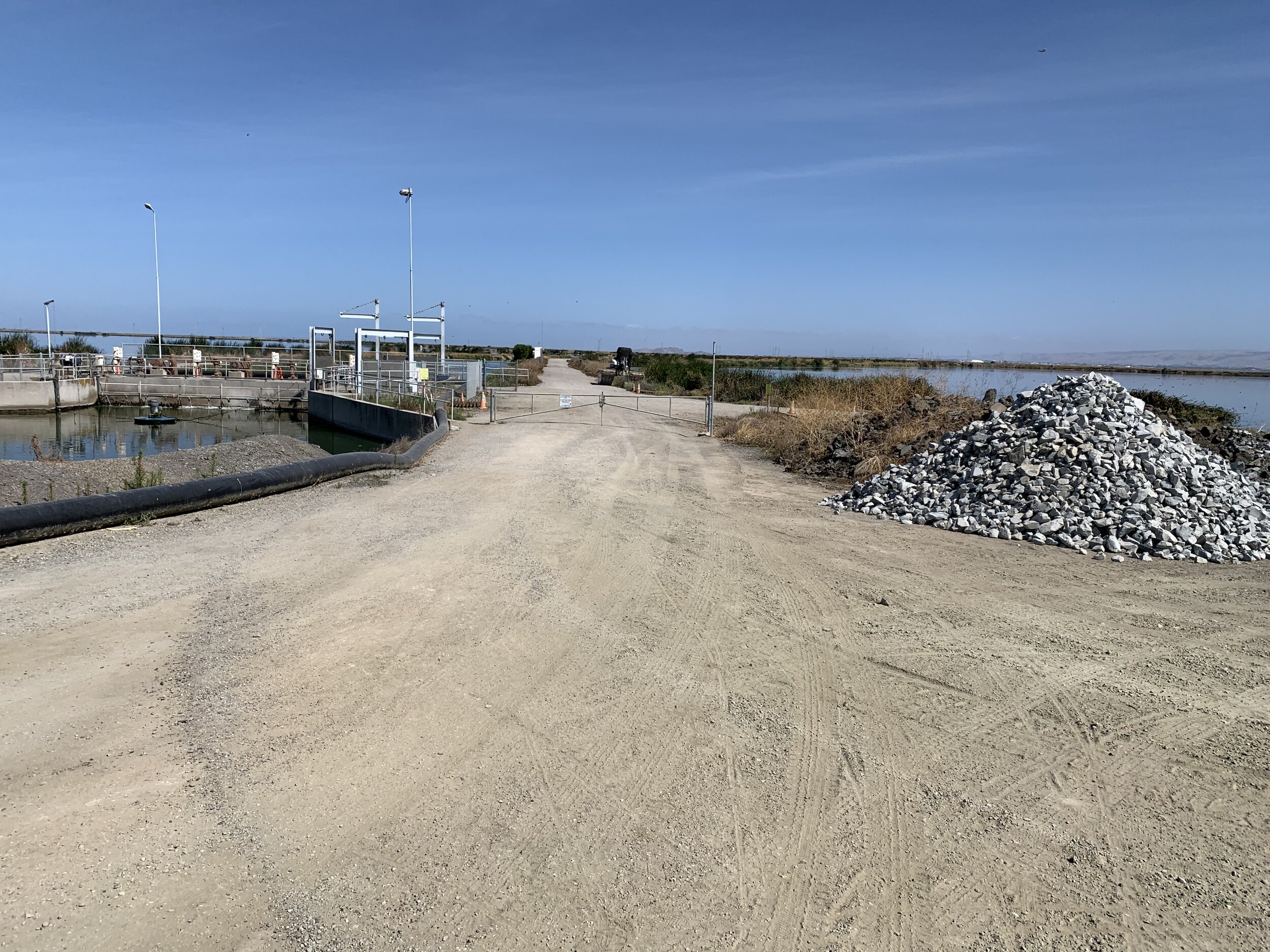
Walk through this gate to access the west side of the East Pond of Sunnyvale Water Pollution Control Plant
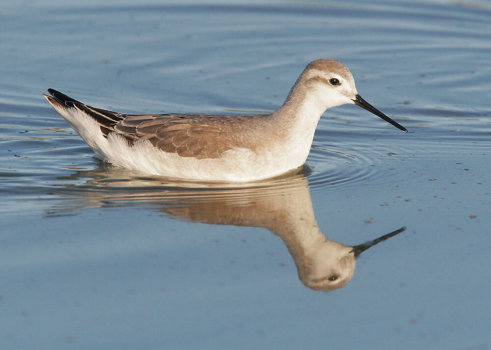
Don't look for Phalaropes foraging on the edges of the ponds; these medium-sized shorebirds feed while swimming on the surface of the water! Also swimming on the pond will be Mallards, Gadwalls, Ruddy Ducks, American White Pelicans, American Avocets and California Gulls but the phalaropes are easy to spot because they are comparatively tiny.
Phalaropes congregate in large flocks as they stop over in the Bay Area on their way to their wintering grounds farther south. These birds are fun to watch: they swim in constant motion picking flies off the surface of the water and use their webbed feet to spin, which creates whirlpools that bring up food to the water’s surface.

Wilson’s Phalaropes. Notice the webbed feet. Photo by Michelle Nelson.
In the Bay Area, we have two common species of phalaropes: the Wilson’s Phalarope and the Red-necked Phalarope. Because these birds are transitioning from their breeding plumage to their winter basic plumage, they can look similar at first glance. So be sure to study your field guide and/or watch the video: Ask BirdGuy 16: Water Spinners and Mud Pipers for identification tips before you head out.

Wilson’s Phalarope on the left, Red-necked Phalarope on the right. Notice that the Red-necked Phalarope is a smaller bird with a shorter neck and a shorter bill. Photo by Garrett Lau taken in June when the birds are transitioning from their breeding plumage to their basic winter plumage.
To learn more about phalarope behavior, watch SFBBO Speaker Series Birdy Hour Talk: Phalaropes in SF Bay with Max Tarjan.
After hopefully spotting the phalaropes, return the way you came or continue on the 2 mile loop trail that circles around the East Pond and will bring you back to the radar tower.
Ready for More?
Trails wrap around both the East Pond and the West Pond of the Sunnyvale Water Pollution Control Plant so there’s lots to explore. I like to visit the West Pond when I’m looking for our summer terns: Forster’s Terns, Caspian Terns, and Elegant Terns. There’s a floating berm on that pond and the terns often rest on it.
You can also return to the Bay Trail (#2 on map) and walk north passing several salt ponds to eventually reach Shoreline Lake Park or return to the trail intersection at Carl Rd (#1 on map) and walk east along the Bay Trail to reach Pond A4 .
Volunteer Opportunity from SFBBO: Calling waterbird aficionados! This summer SFBBO will be conducting phalarope surveys to help us understand how these birds utilize the Bay Area during migration. We are looking for volunteers with good phalarope ID skills who are available to survey on select Tuesdays July-September. If that sounds like you, new volunteers can click here to fill out our online volunteer application, and current volunteers can contact Lead Biologist Gabbie Burns at gburns@sfbbo.org for sign-up information.
Interactive Map
Directions: From CA-237 in Sunnyvale, exit Lawrence Expy/Caribbean Dr. Continue onto Caribbean Dr. In 1.2 miles park along W Caribbean Dr (just past Borregas Ave). Access the Bay Trail from here (shown on the interactive map). Latitude/Longitude: 37.417672, -122.019018
Parking: Paved parking; ADA compliant spots available
Fees: None
Public Transportation: The Borregas Light Rail Station and the bus stop at the intersection of Java Dr and Borregas Ave are each 0.6 mile from the trailhead on W Caribbean Dr next to the parking area.
Trail Hours: Sunrise to sunset
Facilities: Wheelchair accessible porta-potty, often not pleasant, drinking water
Trip Mileage: Trip length about 2 miles with options to extend
Trail Conditions: Wide, flat gravel roads in full sun
Accessibility: All paths are flat and wide but not paved. The parking area is paved, but good birding doesn’t start until you’re on the unpaved dirt roads.
Bikes: These trails are great for bikes
Dogs: Dogs allowed on a 6-ft leash
More Information
eBird hotspot: Sunnyvale WPCP--East Pond
All About Birds: Wilson’s Phalaropes and Red-Necked Phalaropes
BirdGuy with SCVAS Executive Director Matthew Dodder Video 16: Water Spinners and Mud Pipers
SCVAS Field Trip Leader Mike Ambrose’s Sunnyvale WPCP Virtual Field Trip
SFBBO Speaker Series Birdy Hour Talk: Phalaropes in SF Bay with Max Tarjan
More Resources
For more trips like this one, visit Self-guided Field Trips.
Visit the SCVAS Birding Resources page for more information on where to bird, our birding community, birding identification resources, and more.
Read “What to Look for Now” by SCVAS Executive Director Matthew Dodder.
Banner Photo Credit: Wilson’s Phalarope in breeding plumage by Dave Zittin
Last Updated: 06/24/2022
Enjoyed this Trip?
Support the work of Santa Clara Valley Audubon Society and become a member. To contact the trip writer with comments, questions or location updates, please email fieldtrips@scvas.org. You can also post in the comment section below. (If you’d like to post anonymously, type your comment, select “Post Comment”, then simply provide a name, like “Guest”, and select “Comment as Guest”.)