
Ogier Ponds (Winter):
Birding by Bike or Walk-in
by Dani Christensen
Ogier Ponds is a quiet, birdy, freshwater haven located in Morgan Hill along the Coyote Creek Trail. It is the perfect spot to visit during fall and winter to look for wintering waterfowl, gulls, and sparrows. However, the destructive flooding of Feb 2017 collapsed the main road that was used to enter the area, which means birders have to get creative if they want to bird here! This write-up covers how to arrive at Ogier via the Coyote Creek Trail, and to cut down on miles, I recommend going on a bike (or any other non-motorized mode of transportation you prefer!). We’ll go over how to get to Ogier Ponds via bicycle and what to look for once you arrive. This route is about 1.5 miles one-way on a smooth, paved bike trail (with very slight elevation gain in some areas). Mileage may vary depending on how much you explore around the ponds. Remember to check the Santa Clara County Parks website for trail conditions before you go. So bring some water and a snack, put your helmets on, and let’s go!
Walk-in directions are included below.
Key Birds: Ring-necked Duck, Bufflehead, Iceland Gull, Glaucous-winged Gull, Marsh Wren, Lincoln’s Sparrow
Trip Covers: October - March
How to Bird by Bike:
If you are coming from San Jose, you have many options to park a vehicle and ride a bike along the trail, but the closest option is roadside parking at Coyote Creek Golf Dr. off of Monterey Hwy. [1 on interactive map]. Just be mindful of private property and any “No Parking” signs. From here you will hop onto the trail and bike south towards Ogier Ponds.
If you are coming from Gilroy, park at the Anderson Lake Visitors Center [2 on interactive map]. It is almost as close and has a bathroom! Hop onto the trail and ride north towards Ogier Ponds.

Riding along the Coyote Creek Trail in the dappled shade of Western Sycamores. You can see evidence of the August fire in the trees to the left and burned area up ahead. Photo by Dani Christensen
Once you are on the trail (starting from either direction), you’ll notice you are riding along the Coyote Creek. The most noticeable tree providing ample shade is the Western Sycamore, a flood-plain-loving deciduous tree with puzzle-like bark. Along the banks you’ll see water-loving plants like cattail, tule, willows, and mulefat—all essential food and shelter for bird life along the creek. Keeping one eye on the trail and one eye on the creek, check for glimpses of ducks like Hooded Merganser and Wood Duck. You’ll come across a few open fields before you reach Ogier. Scan these fields for Say’s Phoebe, Western Meadowlarks, Northern Harriers, American Kestrel, and groups of Wild Turkey.

View of one of the East Ponds, with American Coots and Ring-necked Ducks on the water. I like to lock my bike up to one of these posts so I can roam the ponds without worrying about my bike. Photo by Dani Christensen
After about a mile-and-a-half from either direction, you’ll reach Ogier Ponds. If you are coming from Gilroy, you will have hit a large field and parking lot where the Santa Clara County Model Aircraft Skypark is [3 on interactive map] . There is a porta-potty there, but only open when the model aircraft park is open, so it’s best to make other plans if you need to go. Ride past this parking lot, et voila! You have made it to Ogier Ponds. The rest of this write-up will cover the southbound direction.
Riding in from the north, you will notice a large pond on your right [4 on interactive map] This is part of Ogier Ponds, and is referred to as the “North Pond” in Birding at the Bottom of the Bay. Across the highway you’ll see Kirby Canyon Landfill in the Diablo Range. We have this landfill to thank for the fantastic diversity of gulls that can be found at Ogier, if you are up to the challenge! Hop off the bike and walk down to the pond edge to get a closer look, where you can search for California, Ring-billed, Herring, Western, Iceland, Glaucous, and Glaucous-winged Gulls in winter. Check out Matthew Dodder’s “Ask Bird Guy Episode 3” on SCVAS’ YouTube Channel to start with identifying Ring-billed and California Gull.
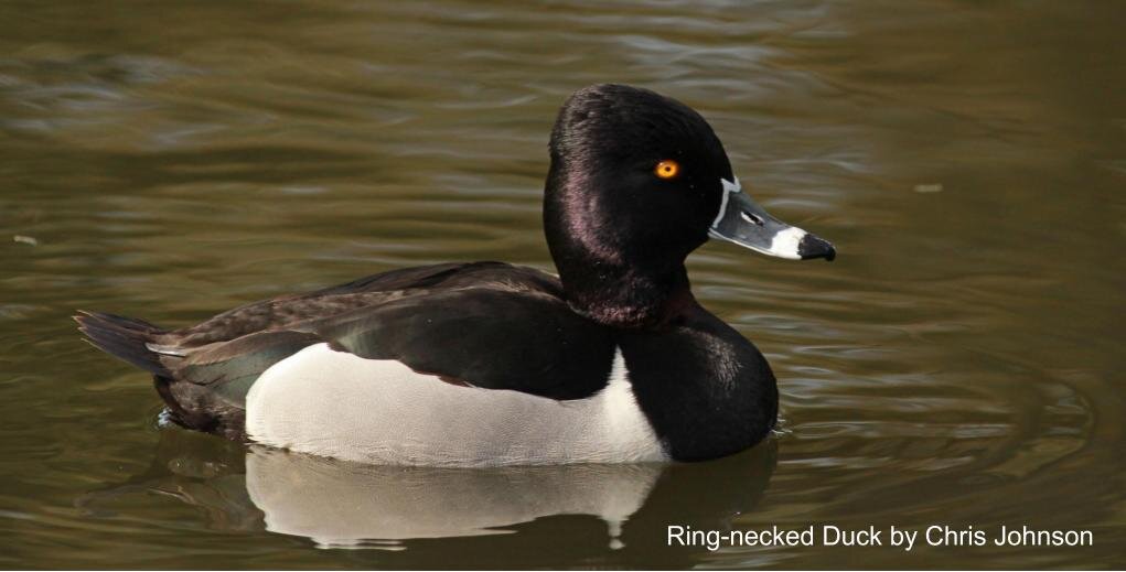
Look for ducks on the ponds such as this beautiful male Ring-necked Duck in breeding or “alternate” plumage. You may think of spring as “breeding time”, but many ducks start courtship in fall & winter, often on their wintering grounds! It’s for this reason you will see ducks in their most colorful & alluring plumage in fall & winter. Photo by Chris Johnson
Hop back on your bike and get back on the trail, cross under two large utility towers and come to a fork in the trail [5 on interactive map]. Take either side, they run parallel to each other for the length of the ponds and you can take the other path on your return.
On your right, you’ll find the “West Pond” [6 on interactive map]. Hop off the bike and walk along the edges, scanning the reeds for water birds like Green Heron, Sora, Black-Crowned Night-Heron, and Common Gallinule. Listen for the harsh song of a Marsh Wren, the call of a Common Yellowthroat, or the racket produced by a Belted Kingfisher. Look on utility poles, wires, and trees for perched raptors such as Peregrine Falcons, Merlin, and the occasional Osprey. Red-Tailed Hawks, Red-Shouldered Hawks, and White-tailed Kites are commonly found here too. Golden Eagles are often seen soaring high above, and Bald Eagles occasionally visit. Both Cooper’s and Sharp-shinned Hawks can be seen here in winter.

Check the power towers and tops of trees for raptors such as this adult Peregrine Falcon. Photo by Dani Christensen
Continue birding on foot south, looking for Lincoln’s, Song, Golden-Crowned, and White-crowned Sparrows in the weedy areas adjacent the trail. Inspecting movement in the shadows of the coyote brush may turn up a Fox Sparrow, Hermit Thrush, or California Thrasher. Quiet observation of the creek can sometimes produce a Wilson’s Snipe or a Sora. Keep going, either on foot or by bike, until you reach the Santa Clara County Model Aircraft Skypark [3 on interactive map]. Check the field for American Pipits, Savannah Sparrows and – if you’re really lucky!— a Ferruginous Hawk.

Lincoln’s Sparrows like this one are superficially similar to Song Sparrows, but are smaller and “daintier”. Check out the fine streaking on their tan flanks, brown crown stripe with black streaks, and small bill. You can tune into their location with their almost electric-sounding, high buzzy call note. Photo by Tom Grey
After observing the model airplane field, turn around and bike the other trail [7 on interactive map] to bird the rest of the ponds on the east side. On your right you’ll come across the “South Pond” [8 on interactive map] and shortly after that the “East Ponds”. Pause to scan the water here for the more common waterfowl such as Mallards, Ruddy Duck and Gadwall, and the “duck-a-likes” such as Pied-billed Grebes and American Coots. The main attraction here is the wintering ducks that show up in fall and stay through winter. These include Ring-necked Duck, Cinnamon Teal, American Wigeon, Northern Shoveler, Green-winged Teal, Canvasback, Bufflehead, Common Goldeneye, and both Lesser and Greater Scaup. That’s a lot of ducks!

A birder enjoying the Ring-necked Ducks on the East Ponds. Photo by Dani Christensen
Walk the trail between the East Ponds to find a bench at the end of the path [9 on interactive map]. I like to sit here for a moment before moving on, having a snack and listening. This is a good spot to lock your bike up on the fence so you don’t have to worry about it while you wander around. If they aren’t flooded, take your time exploring the foot trails that go behind and around these ponds, and you may stumble upon something surprising. For example, American Bittern used to be found here, but have not been reported in some time. With careful observation and patience, perhaps we can see their return.

This Green Heron is perched in the open, but often you will see this waterbird skulking in the reeds along the edge of quiet corners of the ponds. All of a sudden, a flushed Green Heron will make a comical squawking as it flies to a different perch. Photo by Garrett Lau
Walk-in Directions
I highly recommend exploring the other ponds to the west of Coyote Creek Trail by using Ogier Ave off of Monterey Hwy and walking in. Park at the end of the road behind the RV Park and walk east to the ponds [10 on interactive map]. This area has more ponds and is especially quiet, since there is no Creek Trail access from this entrance. I have enjoyed many birdy mornings on this side, but just be aware that parking is limited to a handful of spots. Latitude/Longitude: 37.178275, -121.697060
We’ve contacted the Santa Clara County Parks Department and they discourage the public from using the Barnhart Ave entrance.
Interactive Map
Directions for starting on Coyote Creek Golf Dr (north of Ogier Ponds):
From US-101 S, exit Bailey Ave and turn right on Bailey West. Immediately take the Monterey Rd ramp on your right and turn left on Monterey. Travel south 2 miles, then make a U-turn at Palm Avenue, and make a right on Coyote Creek Golf Course Drive. The trailhead is at the end of the road. Park anywhere on the side of the road, being mindful of No Parking sign in front of private property. Latitude/Longitude: 37.191526, -121.708833 [1 on interactive map]
Directions for starting at Anderson Lake Visitors Center (south of Ogier Ponds):
From US-101, exit Cochrane Rd and head east. Turn left onto Malaguerra Ave and continue into the park, with parking lots on the left. The Coyote Creek Visitor Center at Anderson Lake is next to the parking lots. Latitude/Longitude: 37.166893, -121.649175. Address: 19245 Malaguerra Avenue, Morgan Hill, CA 95037. [2 on interactive map]
Parking: On the side of the road on Coyote Creek Golf Course Drive or paved parking lot at Coyote Creek Visitor Center at Anderson Lake
Fees: None
Trail Hours: Trails are open sunrise to sunset. Parking lot at Anderson Lake Visitors Center open 8am to sunset
Facilities: One ADA-compliant porta-potty is available at the model airplane park. ADA complaint porta-potties, restrooms, and picnic tables are available at Coyote Creek Visitor Center at Anderson Lake.
Trip Mileage: 1.5 - 2 miles one-way
Trail Conditions: Smooth, paved bike trail, with only very slight elevation gain in some areas to reach Ogier Ponds. Additional mileage to bike the length of the ponds and explore on foot.
Accessibility: Coyote Creek Trail is wide, paved, and smooth. Smaller trails around the ponds may be tough for wheelchairs because they are unmaintained dirt trails.
Bikes: This is a great trip to do by bike.
Dogs: Allowed on leash
More Information
Coyote Creek Parkway Trail Map
eBird hotspot: Ogier Ponds
Ask BirdGuy by SCVAS Executive Director Matthew Dodder: Episode 3
More Resources
For more trips like this one, visit Self-guided Field Trips.
Visit the SCVAS Birding Resources page for more information on where to bird, our birding community, birding identification resources, and more.
Read “What to Look for Now” by SCVAS Executive Director Matthew Dodder.
Banner Photo Credit: Black-crowned Night Heron by Julie MacKinnon
Last Updated: 08/20/2022
Enjoyed this Trip?
Support the work of Santa Clara Valley Audubon Society and become a member. To contact the trip writer with comments, questions or location updates, please email fieldtrips@scvas.org. You can also post in the comment section below. (If you’d like to post anonymously, type your comment, select “Post Comment”, then simply provide a name, like “Guest”, and select “Comment as Guest”.)